Mutawintji National Park Geotrail
The Mutawintji National Park Geotrail provides an interactive experience for visitors as they walk the bush trails and beautiful rocky outback landscapes in the park.
Mutawintji National Park Geotrail in far west NSW follows existing walking tracks to explore the park’s ancient geology and Aboriginal cultural significance.
Travel back in time as you see rock formations of Devonian age, rock art and fossils revealing evidence of life up to 500 million years ago.
Mutawintji National Park Geotrail provides an engaging learning experience for those of all ages, making it an ideal location for tourists, locals and educational excursions.
This project was delivered in partnership with NSW National Parks and Wildlife Service, and with guidance from the Mutawintji Board of Management, Mutawintji Local Aboriginal Land Council, local Aboriginal elders, and members of the wider community.
To find out more about this exciting experience, watch the Mutawintji National Park Geotrail video:
NSW GeoTours app
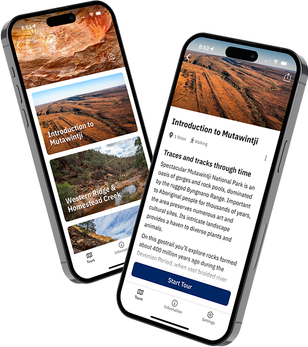
Explore the Mutawintji National Park Geotrail with the free NSW GeoTours app on your smartphone or tablet (Apple and Android). Be sure to download tours before you go as network access is very limited in the area.
Key points of interest have been geotagged to pop up when you reach a site. The app uses your device's GPS to locate you even with limited or no network access.
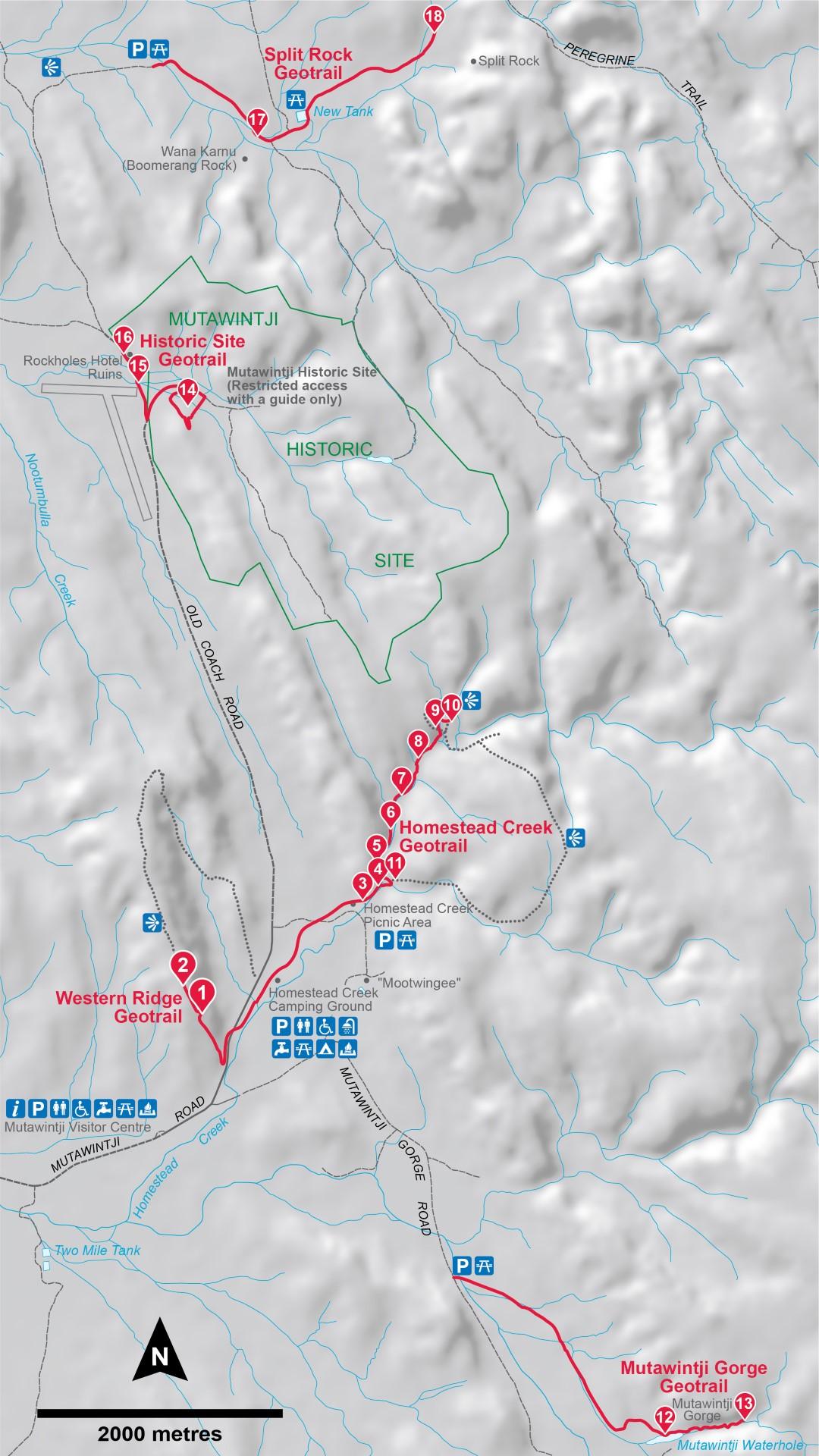
There are 4 tours to download, plus an introduction:
- Introduction to Mutawintji (an overview of the geotrail, geology and general information)
- Western Ridge & Homestead Creek (A walk back in time, stops 1–11)
- Mutawintji Gorge (The power of water, stops 12–13)
- Mutawintji Historic Site (Life and a changing landscape, stops 14–16) Note that the Historic Site requires a pre-booked tour with an authorised guide to visit
- Split Rock (Rocks under stress, stops 17–18).
NSW GeoTours is optimised for mobile devices, but can also be accessed on a web browser.
Visiting the Mutawintji Historic Site

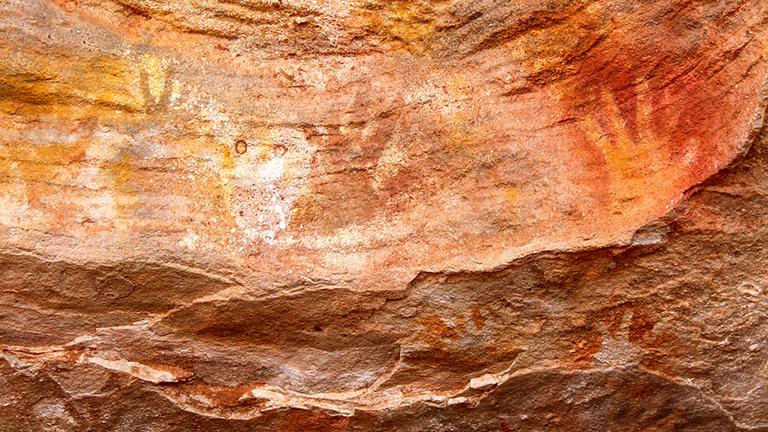
Mutawintji National Park is within the tribal lands of the Pantjikali and Malyankapa people. Mutawintji Historic Site protects a ceremonial centre for Aboriginal people from a wide region and contains important features such as creation places, rock engravings, stencils, paintings and evidence of past occupation.
The Mutawintji Historic Site is a very special ceremonial place where initiation, rain-making and other ceremonies have been held. Some of these events have attracted over 1,000 Aboriginal people from around the region.
The Mutawintji Historic Site is gated and accessible only via booking a guided tour. Visit the NSW National Parks website for more information about the site and booking tours.
Explore online in 3D
Western Ridge & Homestead Creek
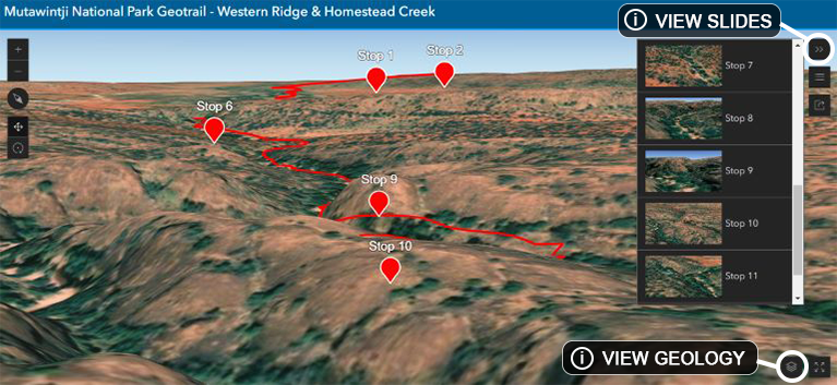
An interactive tour of the Mutawintji National Park Geotrail – Western Ridge & Homestead Creek online in 3D.
Take an interactive tour in 3D
Mutawintji Gorge
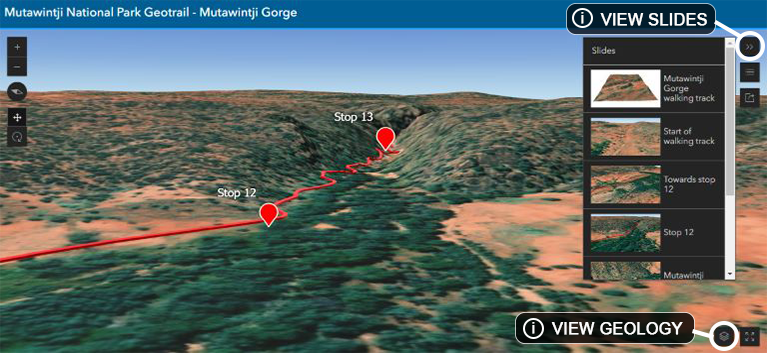
An interactive tour of the Mutawintji National Park Geotrail – Mutawintji Gorge online in 3D.
Take an interactive tour in 3D
Features include:
- Predefined views for each stop using the ‘slides’ feature
- Geology data can be added from the ‘layer list’
- Click on the stops to reveal information about the geology and sites of Aboriginal cultural significance along the geotrail.
A dark sky place

When you camp overnight at Mutawintji you will be able to enjoy spectacular dark skies during the night. Historic Site tour guides will be able to tell you many stories relating to the southern night sky.
Accessibility
Access to the various parts of the geotrail is via pre-existing walking tracks and roads, most of which are unsealed. Some rocky sections of the walking tracks are steep and have steps or ladders to climb. Refer to the app for walking grades for each tour.
Further information
Mutawintji National Park Geotrail brochure (PDF, 2.2 MB)